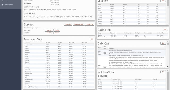
What is the geoportal? Silver Spring Energy Consulting Ltd. has developed a full geological reporting platform for our clients and third party consulting firms. It is a database driven platform for storing, sharing and generating standardized reports for wells as they are drilled. Version 2.0 of Geoportal was released on February 22 2021. Version 2.0 […]
Recycling bags and vials to reduce cost and waste!
Silver Spring Energy Consulting Ltd. has partnered with Dynacore Solutions and Birchcliff Energy to re-use plastic sample vials and canvas sample bags that would otherwise waste space in storage or landfills. It may only be a small initiative, but this winter alone we will be re-using nearly 600lbs of plastic on one project alone and […]
Deploying An Existing Django Application to AWS Ubuntu with Apache
Django is an excellent web framework that allows for excellent integration of geospatial data with other database functionality. The built-in development server is excellent during the development phase and is exceptionally easy to configure, but cannot handle concurrent connections and therefore cannot be used in a production environment. Apache is one of the most commonly […]
Troubleshooting “django-admin is not recognized”
When developing a Django application, one of the first steps is to run the django-admin startproject command from the terminal window. In a Windows environment this can lead to the following error: ‘django-admin’ is not recognized as an internal or external command, operable program or batch file. To fix this, first close the terminal […]
Using UAV mounted methane sensors to to find natural gas leaks
Silver Spring Energy Consulting Ltd. is working closely with Burnt Lake Gas Coop to test and implement an aerial mounted laser methane detection system to quickly cover short segments of high pressure gas distribution lines in areas with challenging ground access due to variable terrain, underbrush and livestock. We are using our brand-new Laser Methane […]
Building Plugin Framework for QGIS 3.x
Part 1 Understanding and creating a new plugin framework QGIS 3.0 can be extended with a wide range of functionality using plugins. While there are thousands of plugins available in the Plugin manager, it is often necessary or advantageous to create your own plugins to automate common tasks or add extra functionality to a workflow. […]
Using PyCharm as an IDE for QGIS 3 plugin development
Developing plugins and other Python scripts can be a daunting task for the uninitiated. Using an IDE (Integrated Development Environment) like PyCharm can help keep everything in one place and even integrates version control systems like Git. Unfortunately, unlike ArcPy you can’t just set the interpreter to the included Python 3.7 installation for QGIS and […]
Installing Geoserver on Ubuntu Linux 18.10
GeoServer is a Java-based software web-server designed for sharing geospatial data on the web. It uses the Web Map Service (WMS) and Web Feature Servce (WFS) standard for sharing web maps and actual geospatial data sets. This allows simple sharing and editing of geospatial data. This document will record a step by step process for […]
Creating Vector Data in QGIS
This will cover creating basic vector data in QGIS. Included here will be instructions on how to create shapefile layers, and GeoPackage layers, and creating new geometry tables within a PostGIS Database. Creating Shapefile Layers Creating Shapefile layers in QGIS is as follows: Open a QGIS project and save the project file in an […]